S

Satellite images show fuel oil spill from Russian tankers in the Black Sea

On December 15, two Russian tankers sank in the Kerch Strait near Crimea. Between 2,500 and 4,500 tons of fuel oil could have been released into the sea. It's a catastrophe for the environmental. In total, the fuel oil stains from Russian tankers that were found at sea from December 18 to January 5 could cover more than 1,000 km² of water surface, which is approximately the area of New York City. 

Читати українською

It's not easy to identify fuel oil stains using satellite imagery, but we've figured out how the pollution has spread by sea in recent weeks. You can learn more below about the methodology.

Detecting a pollution spot is labor-intensive and requires significant computer resources, but it doesn't guarantee automatic spotting, even if it is clearly visible.

Methods for detecting oil pollution from radar images can be divided into three main groups:

Methods based on expert assessment; in essence, this is a visual analysis of the image by a person using a certain set of compliance criteria;

Interactive methods, which involve preliminary automated image processing and subsequent human analysis;

Automated methods, i.e., executable modules or software tools that automatically recognize oil slicks without human intervention.

Ukrainian scientific center of Ecology of Sea (UkrSCES) explains that the sea surface smoothing zones (slicks), which are displayed on radar images as more contrasting black areas against the background of the usual gray water surface, can be divided into three classes:

Slicks caused by marine phenomena (internal waves, vortex structures, upwelling, ice formation, etc. can be the reasons)

Slicks resulting from atmospheric processes (calm zones, wind shadows along the coast, rain cells, gravity waves, etc;)

Slicks formed by substances capable of changing the strength of surface tension are films of various organic compounds, including oil-containing products, films of surfactants, films of biological origin (biogenic films), and films of synthetic surfactants.

To correctly classify a slick, wind speed and direction, current speed and direction, ice conditions, bathymetric data, slick shape and size, oil infrastructure data, etc., must be considered.

Wind causes waves on the water and plays an important role in analyzing detected slicks. At low wind speeds (2-5 m/s), slicks form the thinnest films that are easily carried by the current. They usually exist in the form of long (tens and hundreds of kilometers), often curved or spiral stripes. It is somewhat difficult to recognize oil slicks in areas with large accumulations of biogenic films.

It is also important to analyze the slick in terms of its linear dimensions (length, width), area characteristics, shape, contrast, and type of contour (feather-like, clear, blurred).

Based on the above, it is true that not all black areas seen in Sentinel-1 images are fuel oil.
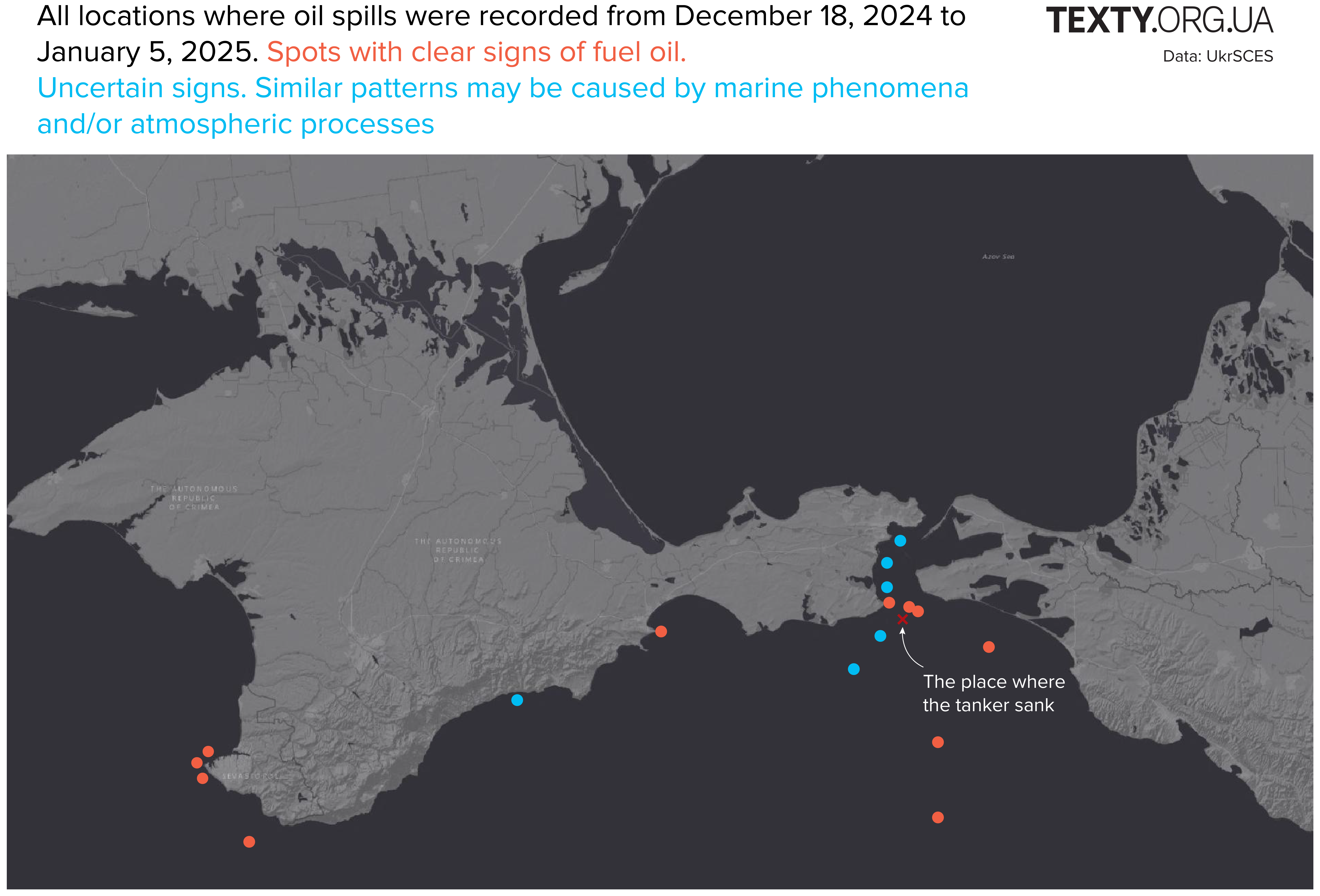
The image is a map displaying locations of oil spills recorded from December 18, 2024, to January 5, 2025, in the region surrounding Crimea and the Azov Sea. It uses red dots to mark spots with clear signs of fuel oil contamination and blue dots to indicate uncertain signs, possibly caused by marine phenomena or atmospheric processes. The map includes an annotation showing the place where a tanker sank, correlating with a cluster of red markers. The map background is gray with coastal features and labels for regions such as "The Autonomous Republic of Crimea."

December 18

The satellite detected the first fuel oil spots on the third day after the accident. In the image from December 18, these are dark areas near the accident site. The stains on both images are about 10 km long.
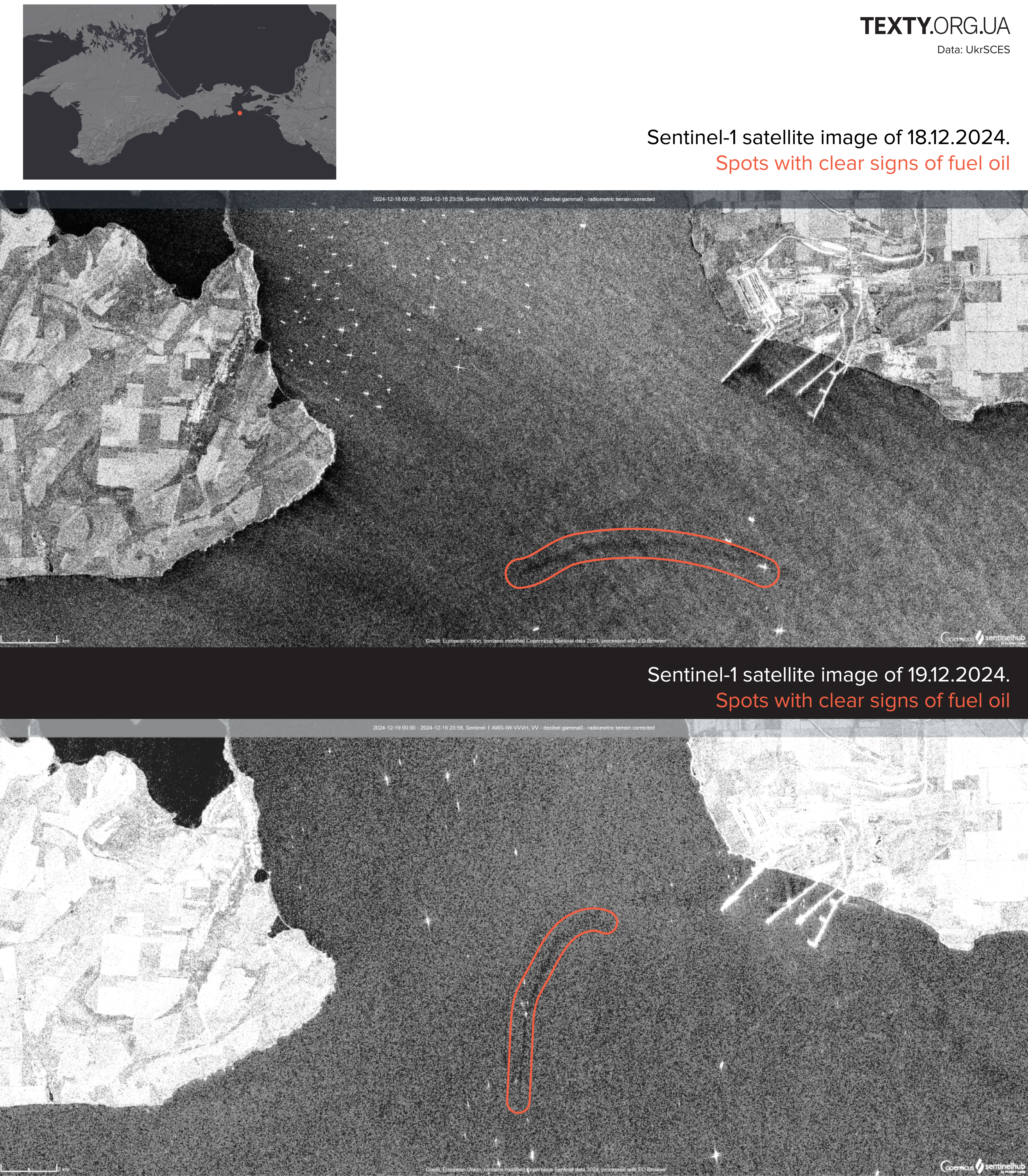
The image contains two Sentinel-1 satellite images taken on December 18 and December 19, 2024, showing areas with clear signs of fuel oil contamination in the sea near the coastline.  Top Satellite Image (December 18, 2024): A red outline marks a linear pattern of fuel oil on the water surface near the coast. The surrounding grayscale imagery depicts coastal land features, including agricultural fields and structures near the shoreline.  Bottom Satellite Image (December 19, 2024): Another red outline highlights a distinct curved pattern of fuel oil contamination, also near the coast but slightly different in location compared to the previous day.  Above the satellite images, a smaller inset map provides a broader geographical context of the affected region. The map includes a red marker to identify the approximate location of these observations. The images aim to document the progression and spread of the oil spill over time.

Analysis of the images shows the movement of fuel oil in the direction of the Azov Sea.

December 19

Another satellite image from December 19 shows a fuel oil slick about 35 km long off the coast of the Krasnodar Region of Russia.
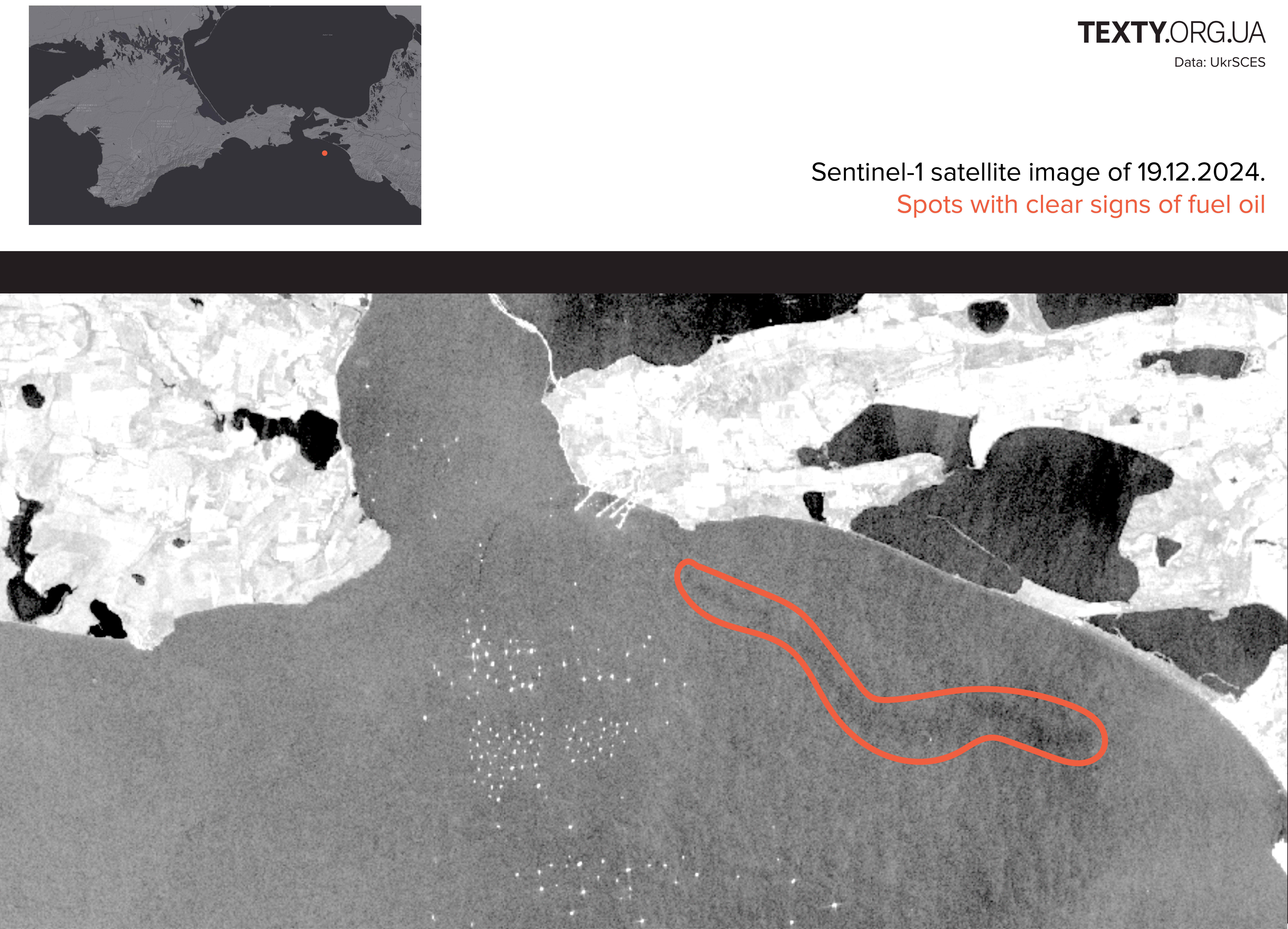
The image displays a Sentinel-1 satellite image taken on December 19, 2024, highlighting a specific area of water near the coast. A red outline marks a region identified as having clear signs of fuel oil contamination. Above the satellite image, a smaller map provides a geographical reference to locate the contaminated area. The grayscale satellite imagery shows land and sea, with a notable dark area near the shoreline corresponding to the outlined contamination. The image emphasizes the environmental impact of the spill, as indicated by the clear markings.

December 23

Black spots visually similar to fuel oil appear in the Kerch Strait off the eastern coast of Crimea. However, the Ukrainian scientific center of Ecology of Sea doubts that these spots are caused by oil products or only by them, as some atmospheric processes may appear similarly on satellite images.
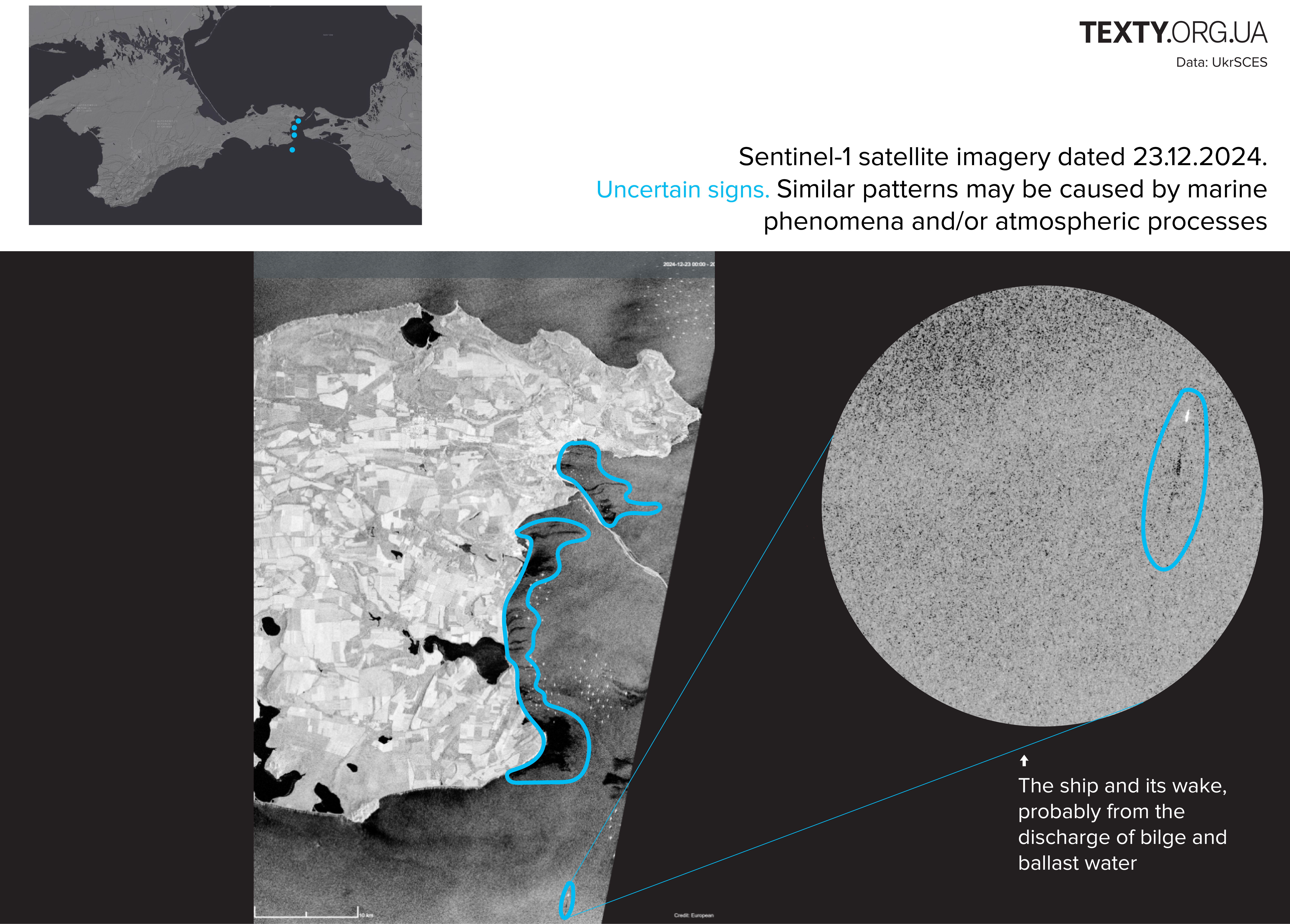
The image contains Sentinel-1 satellite imagery dated December 23, 2024, indicating uncertain signs of environmental phenomena. These patterns are highlighted in blue and may have been caused by marine phenomena and/or atmospheric processes.  Left Section (Main Satellite Image): A detailed grayscale image of the coastal area shows a prominent blue outline following a winding path along the coast, suggesting possible environmental impacts or contamination. This area could reflect anomalies in water patterns, though their cause is uncertain.  Right Section (Magnified View): A zoomed-in circular view highlights a ship and its wake, marked by a smaller blue outline. The description suggests this is likely caused by the discharge of bilge and ballast water from the vessel, potentially contributing to the observed patterns.  Top Inset Map: Provides a geographical reference, marking the general location of the satellite observations with blue dots on a larger map.  The visuals aim to document and analyze ambiguous environmental signs while pointing to potential sources such as ship activity.

The detailed image above shows the ship (bright white dash) and the wake behind it (dark spot), which is likely the result of the discharge of bilge water (a mixture of water, oil residues, fuel waste, oils, and other substances that accumulate in the bilge compartments of ships). The length of the wake is 4 km. This is also pollution, but it's not related to the accident on December 15.

December 29

On December 29, an image from December 29 shows oil spots characteristic of oil products off the southern coast of Crimea, 17 km from Cape Sarych. The total area of the detected spot is 160 km², the maximum length is about 25 km, and the width is 11 km. For comparison, this is approximately equal to the area of Miami, the USA (143 km²).
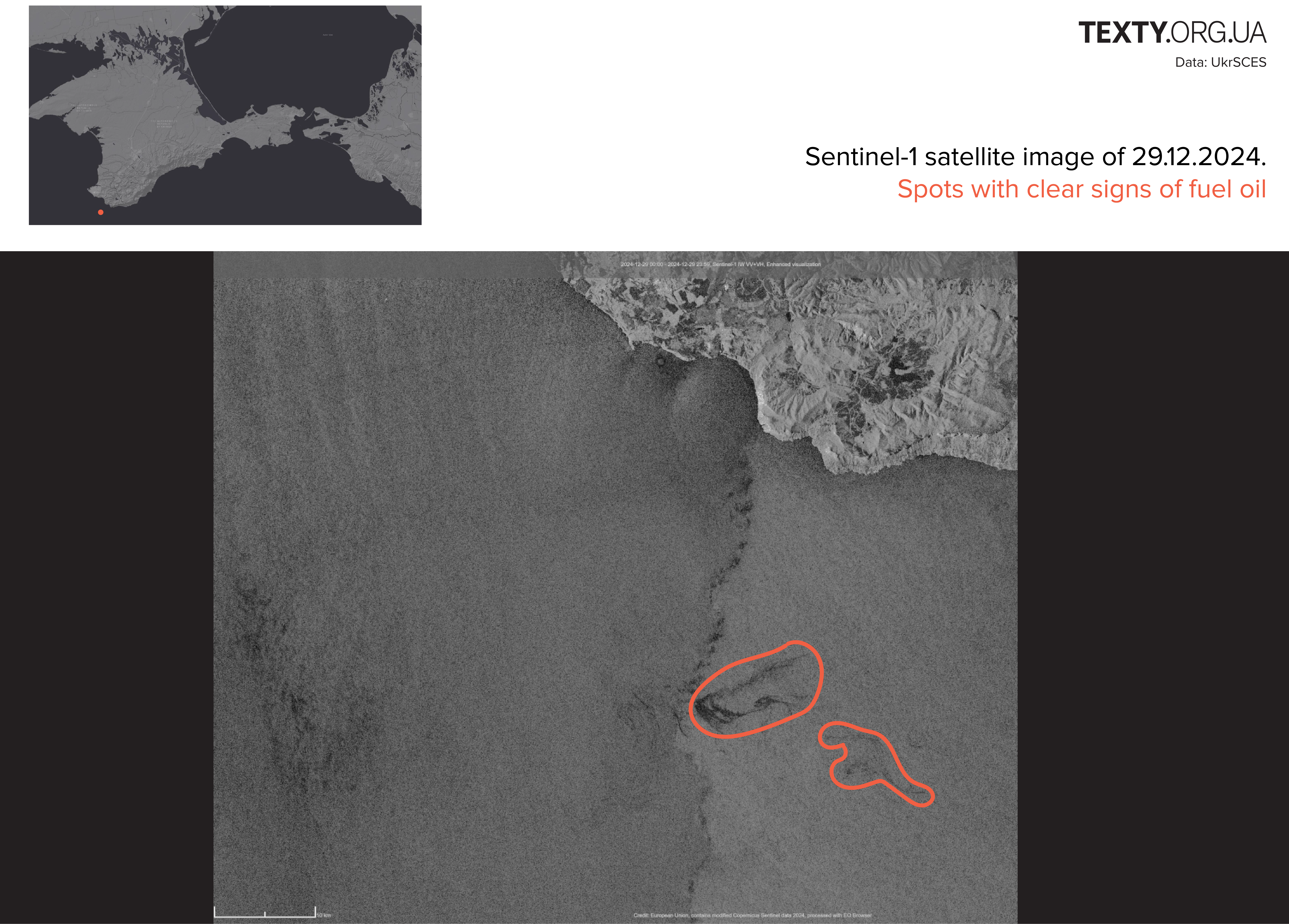
The image presents a Sentinel-1 satellite capture from December 29, 2024, depicting spots with clear signs of fuel oil contamination in the sea near the coastline.  Top Inset Map: A smaller map in the upper-left corner provides a geographical reference to the location of the observed contamination, marked with a red dot in the region near Crimea.  Main Satellite Image: The grayscale satellite image shows coastal features and surrounding water. Two distinct areas of contamination are highlighted with red outlines. One area features a dark, concentrated pattern consistent with a spill, while the other shows a more dispersed pattern of fuel oil.  The image aims to document the environmental impact of a fuel oil spill and provides clear visual evidence of the affected areas.

December 30

The image shows a spot of pollution about 30 km long south of the village of Volna in the Krasnodar Region of Russia. The area of the spot reaches 30 km².
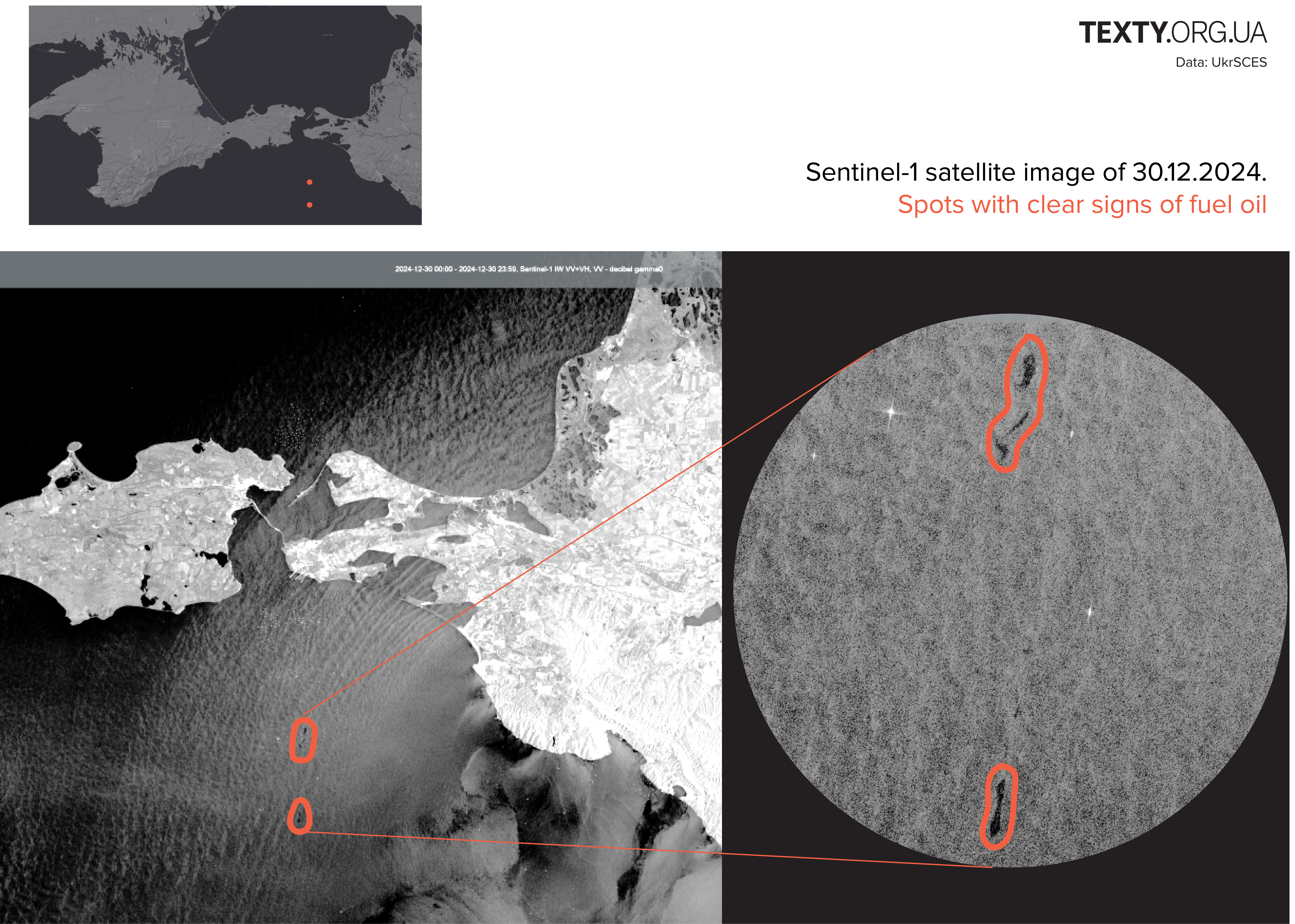
The image shows a Sentinel-1 satellite image dated December 30, 2024, documenting spots with clear signs of fuel oil contamination in the sea near the coastline.  Top Inset Map: A small reference map in the upper-left corner highlights the general location of the observed oil spill, marked with red dots.  Main Satellite Image: The grayscale satellite image captures the coastline and surrounding sea, with red outlines marking two distinct areas of fuel oil contamination in the water. These areas appear elongated and concentrated, likely indicating spill activity.  Magnified View: A zoomed-in circular view focuses on the areas highlighted in red in the main image, providing greater detail of the fuel oil patterns visible on the water surface.

December 31

The satellite spotted two spots at the entrance to the Kerch Strait from the Black Sea: a larger one with an area of about 10 km² and a smaller one with an area of 3 km² at a distance of 28-30 km south of Cape Opuk.
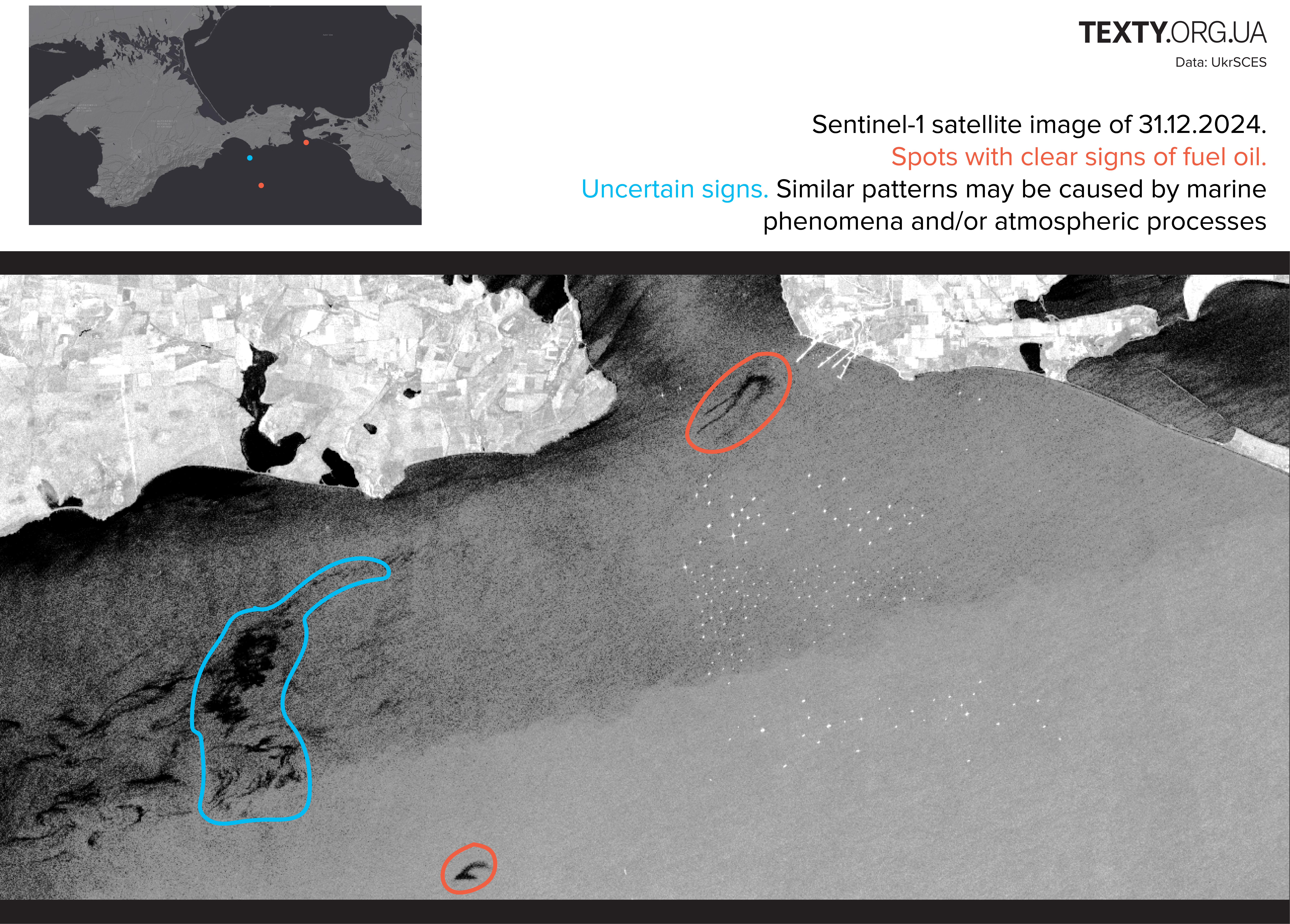
The image features a Sentinel-1 satellite capture from December 31, 2024, showcasing both spots with clear signs of fuel oil and uncertain patterns potentially caused by marine or atmospheric phenomena.  Top Inset Map: A small map in the upper-left corner provides geographic context, highlighting the locations of observations with red and blue dots. These correspond to confirmed and uncertain signs, respectively.  Main Satellite Image:  Red Highlights: Two areas marked with red outlines indicate clear signs of fuel oil. One is closer to the shore and shows a distinct dark trail, while the other is smaller and located further out in the sea. Blue Highlight: A large, irregularly shaped area near the coast is marked with a blue outline, suggesting uncertain patterns that may be linked to natural marine or atmospheric phenomena rather than contamination.

Why is it so difficult to identify the stains?

The patterns in the image from December 24 look very similar to oil slicks, but most likely they are not.
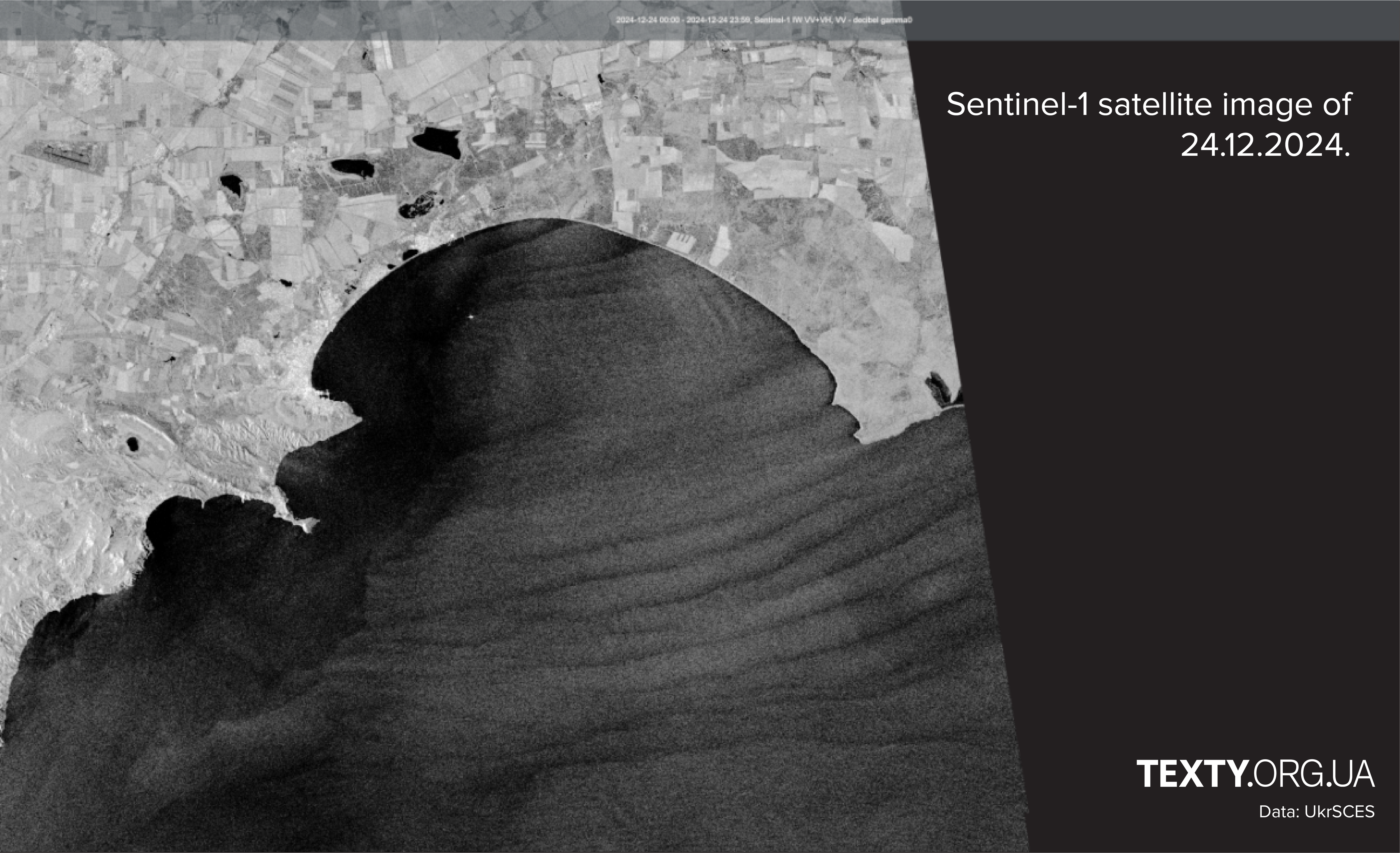
 The image displays a Sentinel-1 satellite capture from December 24, 2024. It focuses on a coastal area where distinctive patterns in the water are visible. The grayscale satellite imagery shows:  Coastline Details: The landmass, including fields, vegetation, and some water bodies, is clearly outlined near the shoreline.  Wave-like Patterns in the Water: The sea surface exhibits noticeable parallel, wave-like streaks extending outward from the coast. These patterns could indicate marine or atmospheric processes, though their specific origin is not identified in the image.

The dark streaks near the Gulf of Feodosia, stretching from east to west, are most likely caused by the wind, as the Ukrainian scientific center of Ecology of Sea explains. Strong winds lead to the spread of pollution, which is exactly what happened, as soon after, reports of fuel oil were found near Sevastopol, Feodosia, and other cities along the southeastern, southern, and western coasts of Crimea.

January 4

The image shows oil stains covering an area of about 2 km² near Feodosia and 0.25 km² near Cape Takil. There is less certainty about the pollution between Partenit and Sudak.
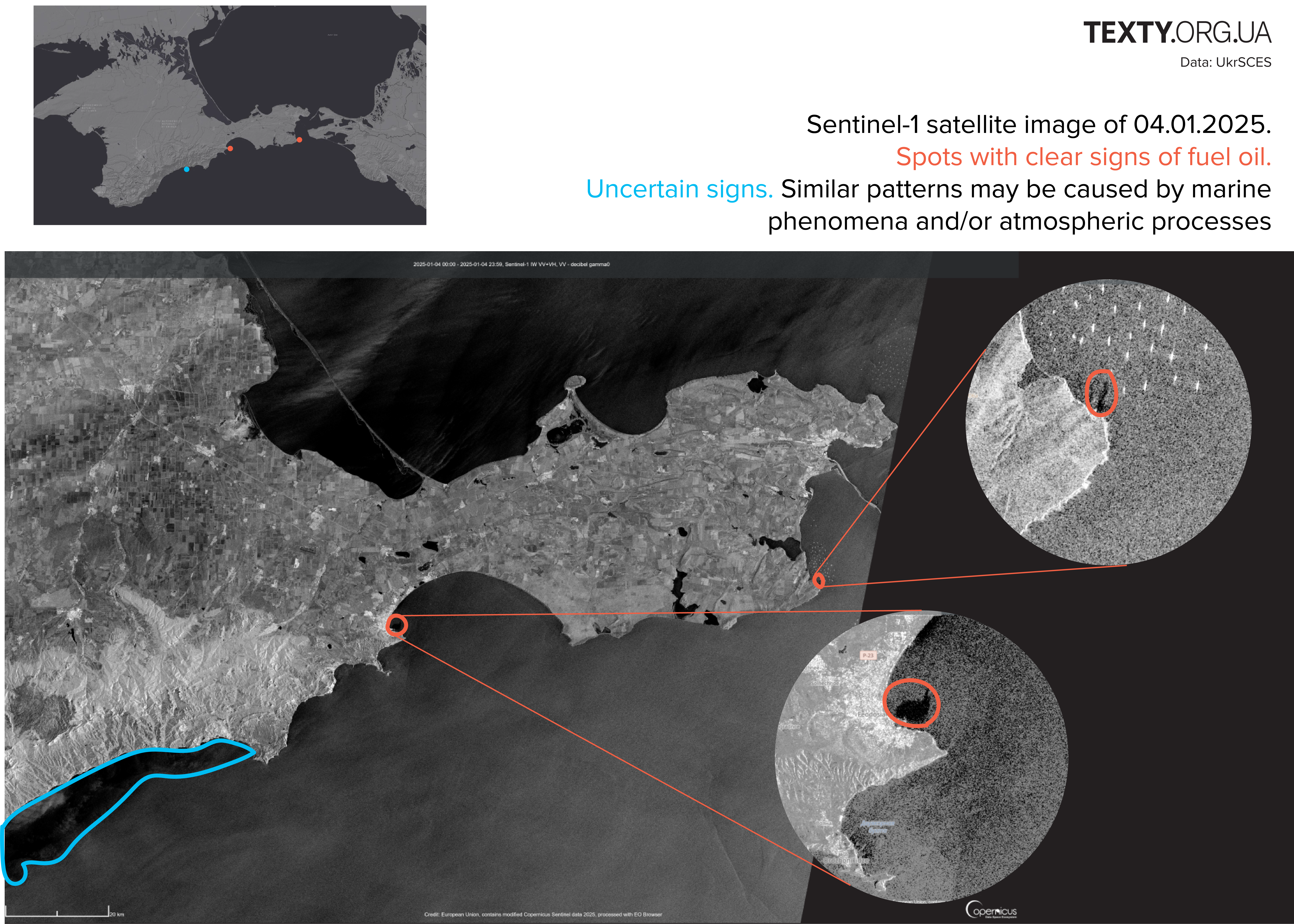
The image presents a Sentinel-1 satellite capture dated January 4, 2025, showcasing both confirmed and uncertain signs of fuel oil contamination in a coastal region.  Top Inset Map: A map in the top-left corner provides a geographic overview of the region, marking observed spots with red (clear signs of fuel oil) and blue (uncertain signs) dots for context.  Main Satellite Image: A grayscale satellite view highlights:  Red Outlines: Two locations along the coast marked with red circles, indicating clear signs of fuel oil contamination. Blue Outline: An irregularly shaped area marked with blue near the bottom-left of the image, denoting uncertain signs potentially caused by marine or atmospheric phenomena. Magnified Views: Two zoomed-in circular insets focus on the red-highlighted locations:  The first shows a coastal segment with a visible dark pattern consistent with oil contamination. The second focuses on another coastal area, where darker anomalies suggest clear signs of fuel oil. This composite image visually identifies and differentiates between confirmed contamination and uncertain environmental phenomena in the monitored coastal region.

January 5

On January 5, fuel oil was spotted near Sevastopol and the village of Kacha north of Sevastopol. The total area of the contaminated water area near Sevastopol reaches 1000 km².
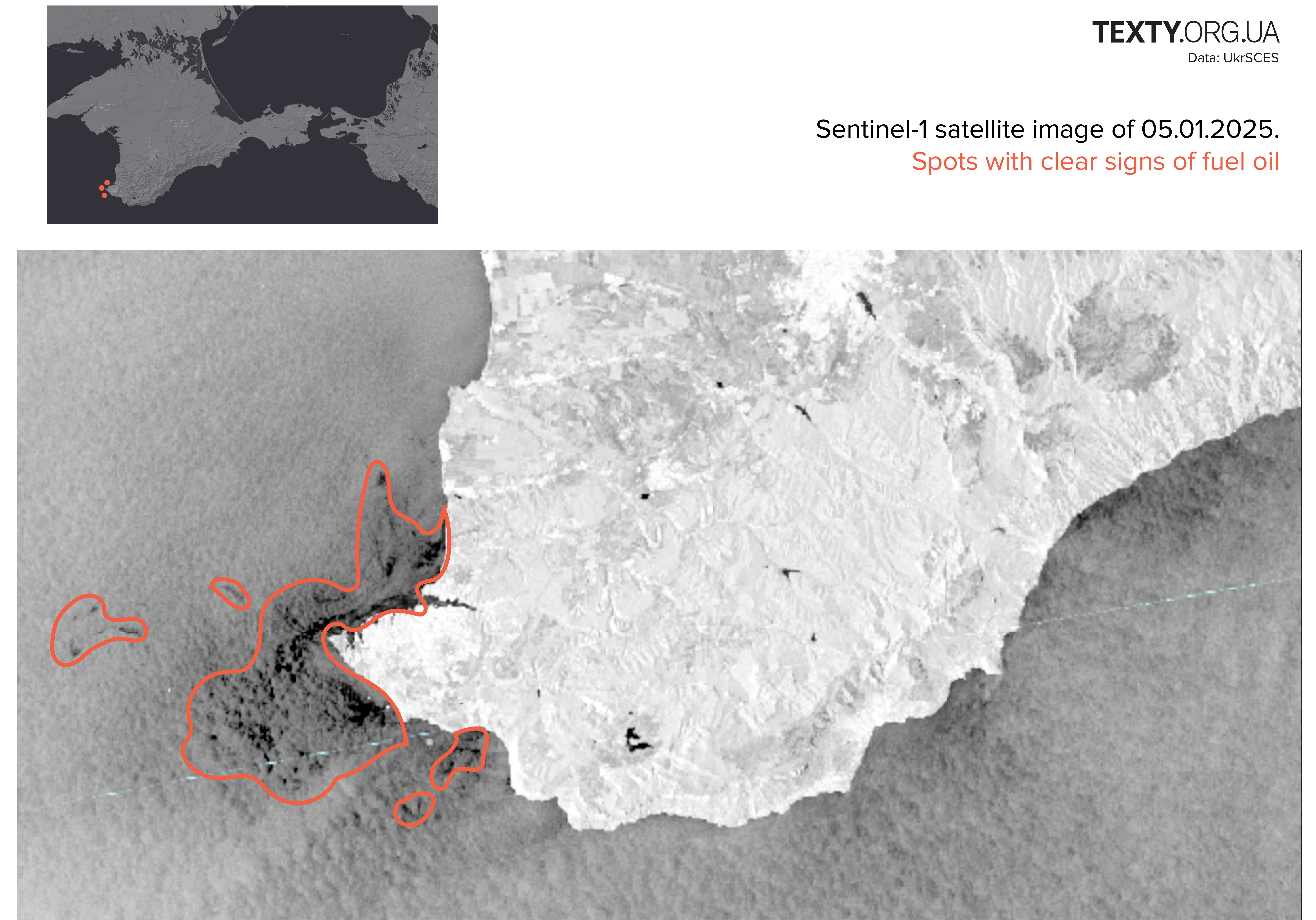
The image displays a Sentinel-1 satellite capture dated January 5, 2025, focusing on spots with clear signs of fuel oil contamination.  Top Inset Map: A small reference map in the top-left corner highlights the geographic location of the observed contamination, marked with red dots near the southwestern coast of Crimea.  Main Satellite Image: The grayscale image shows:  Red Outlines: Multiple irregularly shaped areas in the water near the coastline are highlighted, indicating distinct patterns of fuel oil contamination. The largest area is located close to the shore, with smaller patches dispersed further out to sea. The contamination appears concentrated, suggesting recent spill activity or ongoing leakage in the monitored region. This satellite image highlights the environmental impact of fuel oil contamination and provides detailed visual evidence of its spread along the coast.

Environmental impacts

Fuel oil is a heavy residual oil product that has a toxic effect on marine life. It causes poisoning of fish and other organisms, and disrupts food chains in the marine ecosystem. It can take decades for some species to recover.
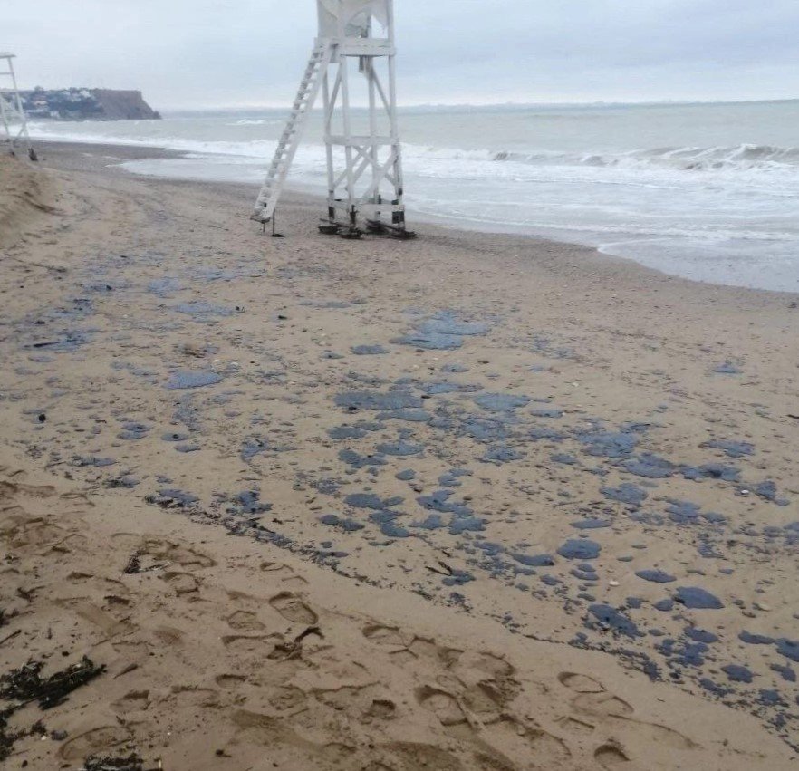
Photo: Association of Reintegration of Crimea

Over the past three weeks, the media have been reporting cases of animal and bird deaths and traces of fuel oil in the coastal areas of Crimea and on the Black Sea coast of Russia.

A massive stranding of dolphins in the Krasnodar region has already been reported. Environmentalists warn of the possibility of long-term pollution. There is also a risk of biodiversity decline in the region.

oil eng russo-ukrainian war environmental

Знак гривні
Знак гривні